
SERVICE 03 / 04 — 32.9346° N, 97.2517° W
Application Development
Custom, production-grade applications across desktop, web, and mobile — every surface built on a shared API, geoprocessing, and spatial-database backbone so data stays consistent no matter which application a user opens.
TRUSTED BY
INDUSTRY LEADERS





THE PROBLEM
Off-the-shelf GIS software wasn't built for how your teams actually work.
Every engagement is scoped across three delivery surfaces, chosen to match how a specific user group works: field crews need offline-capable mobile apps, engineering teams need desktop tools that integrate directly with CAD and structural-analysis software, and stakeholders need browser-based portals and dashboards accessible from anywhere — all on one shared API, geoprocessing, and spatial-database backbone.
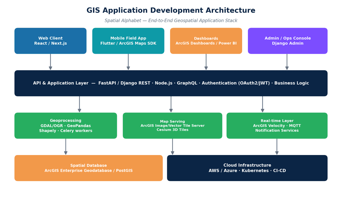
FIG. 03 — APPLICATION DEVELOPMENT WORK PRODUCT
WHAT WE DELIVER
Scannable scope, no mystery line items.
Delivery surfaces & platform
One shared backbone under desktop, web, and mobile.
Desktop (ESRI, QGIS Customizations)
Native ArcGIS Pro add-ins (ArcGIS Pro SDK, .NET, Python) and QGIS plugins that automate geoprocessing, batch validation, and format conversion via ArcPy — integrating directly with PLS-CADD, PLS-POLE, SPIDAcalc, and O-Calc Pro APIs, extending to 3D digital-twin authoring.
Web Apps
Enterprise-grade interactive web applications and dashboards built with React, Next.js, and the ArcGIS Maps SDK for JavaScript — including PWA offline patterns, AI copilot interfaces, and in-browser 3D digital-twin viewers with CesiumJS and WebGL.
Mobile Apps
Offline-capable field apps built with Flutter, React Native, and the ArcGIS Maps SDK for Native Apps, with high-accuracy GNSS, AR overlays for buried/overhead assets, and on-device AI (TensorFlow Lite, Core ML) that flags defects the moment a photo is captured.
Big Data Analytics
Large-scale processing and analytics pipelines over infrastructure and geospatial datasets, surfaced through ArcGIS Dashboards and executive reporting — pattern detection and predictive insight, not static reports.
Automation with AI/ML
On-device and cloud AI/ML for defect detection, GeoAI feature matching and classification during conflation, and automated QA/QC — cutting manual review across the engineering and geospatial pipelines.
Product Development
End-to-end product builds — architecture, UX, and deployment — hosted on Docker/Kubernetes and AWS/Azure with CI/CD delivery.
Custom Software Solutions
Bespoke software tailored to your workflows and integrations, built on the same FastAPI/Django REST, GraphQL, and Node.js backend shared across every Spatial Alphabet product.
TOOLS & PLATFORMS
- REACT
- NEXT.JS
- ARCGIS MAPS SDK
- FLUTTER
- REACT NATIVE
- FASTAPI
- DJANGO REST
- GRAPHQL
- DOCKER/KUBERNETES
- AWS/AZURE
HOW AN ENGAGEMENT RUNS
Four steps. QC gates at every one.
01 — DISCOVERY
We map the workflow, the users, and the systems the application must live between.
02 — PROTOTYPE
A working slice in weeks — real data, real devices, real feedback before full build.
03 — BUILD & INTEGRATE
Iterative delivery on a shared API/geoprocessing/spatial-DB backbone, with automated testing.
04 — OPERATE
Cloud deployment, monitoring, and a support path that doesn't end at launch.
WHERE THIS SERVICE LANDS
Related industries
PILOT PROGRAM
Scope a pilot for application development.
Scope a Pilot →Paid or pro bono — your call. We take a real slice of your program, deliver it to production standard, and you evaluate the result before committing anything further.
01 — SCOPE
We define a bounded, representative work package with you — real data, real specs, one to three weeks.
02 — DELIVER
Our dual-shore team executes under the same QC protocol as a full engagement. No demo-grade shortcuts.
03 — EVALUATE
You audit the deliverables against your own acceptance criteria. Then decide — with evidence, not promises.