
SERVICE 02 / 04 — 32.9346° N, 97.2517° W
AI Powered — Geospatial
GeoAI-driven processing that reconciles heterogeneous spatial data into a single, authoritative, decision-ready dataset — the data engine behind every mapping, analytics, and application deliverable.
TRUSTED BY
INDUSTRY LEADERS







THE PROBLEM
Field GPS, as-built CAD, legacy GIS, and imagery that never agree.
Spatial Alphabet takes field GPS surveys, as-built CAD drawings, legacy GIS geodatabases, and satellite or drone imagery and reconciles them into one authoritative dataset through GeoAI-driven feature matching — spatial proximity analysis combined with computer-vision and machine-learning similarity scoring — followed by geometry snapping, rubber-sheeting, attribute reconciliation, and topology validation. On a live flood-monitoring initiative, we conflated rainfall, weather-station, DEM terrain, and flood-zone data into a single geodatabase feeding an automated SMS/WhatsApp/push alerting pipeline.
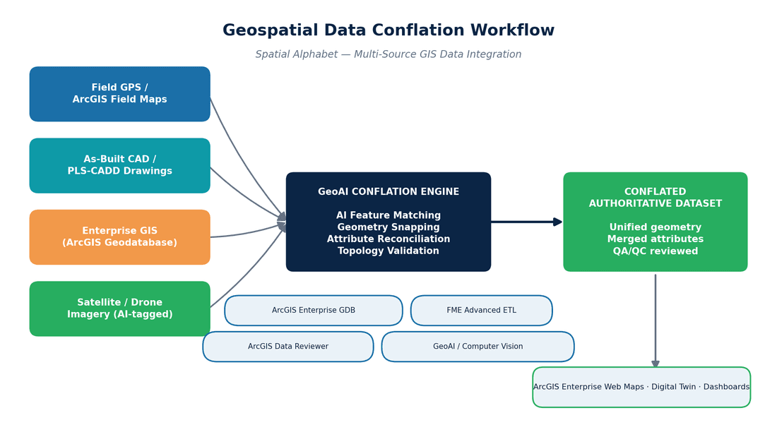
FIG. 02 — AI POWERED — GEOSPATIAL WORK PRODUCT
WHAT WE DELIVER
Scannable scope, no mystery line items.
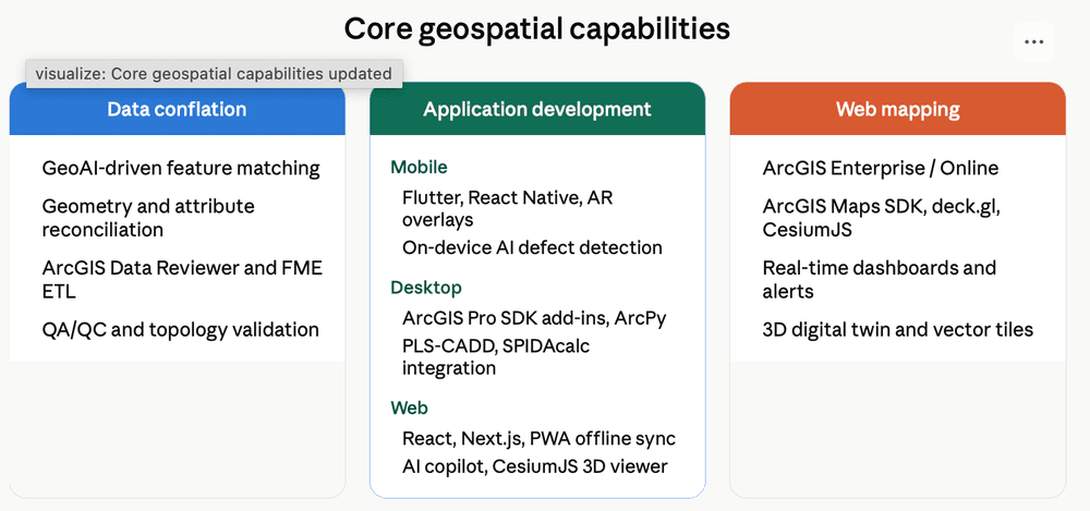
Core geospatial capabilities
Every capability feeds one authoritative, decision-ready dataset.
LiDAR Mapping
High-density point-cloud capture from airborne, drone, or terrestrial LiDAR for terrain modelling, NESC vegetation-encroachment analysis, and utility corridor mapping — feeding pole loading and make-ready.
LULC Mapping
AI-assisted Land Use / Land Cover classification from satellite and aerial imagery — tracking vegetation, built-up areas, water bodies, and terrain change over time for route planning, environmental review, and siting.
Utility Mapping
Poles, conductors, underground lines, and substations mapped into GIS-ready datasets for asset management, network planning, and permitting support.
Vectorization
Raster imagery, scanned drawings, and legacy maps converted into structured, editable vector GIS layers through GeoAI feature matching, geometry snapping, and topology validation.
TOOLS & PLATFORMS
- ESRI ARCGIS
- QGIS
- FME
- POSTGIS
- GEOAI / COMPUTER VISION
- LIDAR
- QFIELD
- GRAFANA
HOW AN ENGAGEMENT RUNS
Four steps. QC gates at every one.
01 — AUDIT
We inventory your data sources, formats, and target systems, and define the acceptance spec together.
02 — PILOT
A bounded slice — one county, one corridor, one dataset — delivered to production standard.
03 — CONFLATION
GeoAI feature matching, snapping, and reconciliation into one authoritative dataset, QC-reviewed.
04 — SUSTAIN
Documented workflows, update cycles, and support so the data stays decision-ready.
WHERE THIS SERVICE LANDS
Related industries
PILOT PROGRAM
Scope a pilot for ai powered — geospatial.
Scope a Pilot →Paid or pro bono — your call. We take a real slice of your program, deliver it to production standard, and you evaluate the result before committing anything further.
01 — SCOPE
We define a bounded, representative work package with you — real data, real specs, one to three weeks.
02 — DELIVER
Our dual-shore team executes under the same QC protocol as a full engagement. No demo-grade shortcuts.
03 — EVALUATE
You audit the deliverables against your own acceptance criteria. Then decide — with evidence, not promises.